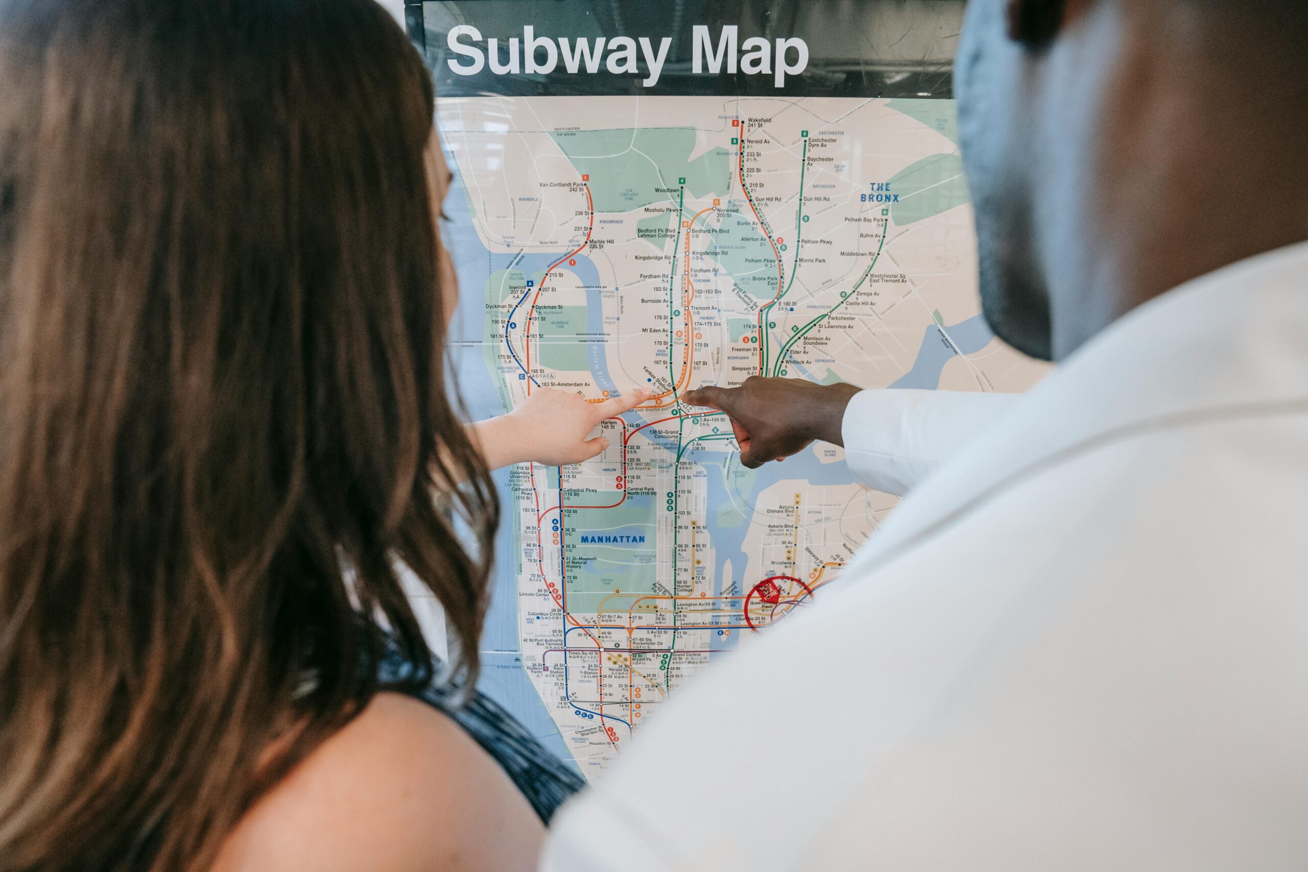
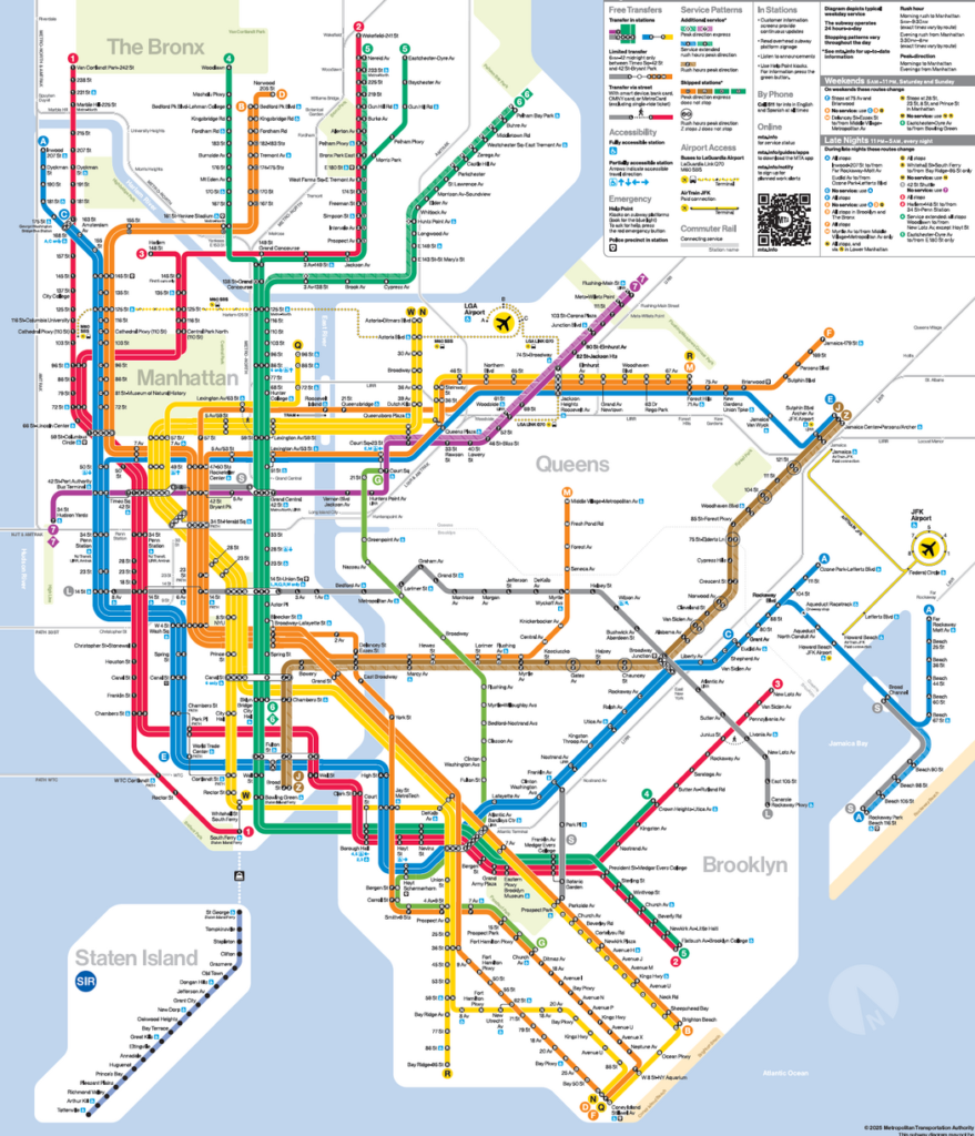
In a major overhaul that marks a new chapter for New York City’s transit system, officials have released a redesigned subway map. This update not only modernizes a beloved navigational tool but also integrates innovative features aimed at enhancing usability, accessibility, and connectivity for millions of riders.
A Modern Design for a Timeless System
The new subway map builds on decades of tradition while addressing the evolving needs of a growing metropolis. Key highlights of the redesign include:
- Streamlined Aesthetics:
The map’s design features cleaner lines, updated color palettes, and a more intuitive layout. This modern aesthetic not only makes it visually appealing but also easier to read, helping riders quickly identify routes and transfers. - Simplified Navigation:
By reducing clutter and highlighting major routes, the new map improves clarity for both daily commuters and first-time visitors. Enhanced legibility means that users can plan journeys with greater confidence, even during peak travel times. - Accessibility Enhancements:
Special attention has been paid to ensuring that the map is accessible to all. High-contrast color schemes, larger fonts, and tactile elements are integrated to assist visually impaired riders, making public transit more inclusive.
Integrating Technology with Transit
Beyond its visual makeover, the new subway map is designed to complement the digital age:
- Digital Integration:
The redesigned map seamlessly integrates with the MTA’s mobile apps and website, providing real-time updates, service alerts, and interactive features. Riders can tap on stations for details about upcoming trains, delays, or alternative routes. - Augmented Reality (AR) Features:
Early trials of AR capabilities allow users to point their smartphones at the map and receive animated directions and historical context about the stations, blending the past with the present in a dynamic way. - Data-Driven Insights:
Enhanced digital mapping supports data collection on passenger flow, enabling transit authorities to better understand travel patterns and make informed decisions about service improvements and future expansions.
Community Impact and Rider Experience
The new subway map is more than just a design update—it’s a tool that promises to improve the everyday experience of New Yorkers:
- Easing Congestion:
By clarifying route options and transfer points, the map aims to reduce confusion and streamline passenger movement, which could help alleviate congestion during rush hours. - Tourist-Friendly Features:
Special landmarks, cultural hotspots, and points of interest are now marked more clearly, making it easier for tourists to explore the city and navigate its rich tapestry of neighborhoods. - Local Engagement:
The MTA involved community groups, historians, and transit experts during the redesign process to ensure that the map reflects the city’s diverse cultural heritage while addressing the practical needs of its riders.
Historical Context and Future Outlook
New York City’s subway system is steeped in history, and the map’s evolution mirrors the city’s growth:
- A Legacy of Innovation:
From its inception in the early 20th century to the digital enhancements of today, the subway map has always been a symbol of NYC’s dynamic spirit. This latest update is part of a broader initiative to modernize the system while honoring its storied past. - Future Expansion:
The new map is designed to be adaptable. With upcoming service expansions, including new routes and station upgrades, the design can evolve further without compromising on clarity or functionality. - Sustainability and Resilience:
Enhanced digital tools and real-time updates support efforts to create a more resilient transit system, one that can better respond to emergencies, infrastructure challenges, and the shifting demands of urban mobility.
Frequently Asked Questions
Q: What are the main changes in the new subway map design?
A: The new map features a streamlined aesthetic with clearer route indications, simplified transfers, improved accessibility elements, and integration with digital platforms for real-time updates.
Q: How does the new map benefit visually impaired riders?
A: The design includes high-contrast colors, larger fonts, and tactile elements to ensure the map is accessible to users with visual impairments.
Q: Will the new subway map replace all previous versions?
A: Yes, the new design will be the official map used across the city’s transit system, both in print and digital formats, with regular updates as needed.
Q: How does digital integration enhance the rider experience?
A: The map integrates with mobile apps and websites to offer real-time service updates, interactive features, and augmented reality tools that provide additional navigation assistance and historical context.
Q: What role did community feedback play in the redesign?
A: Community groups, historians, and transit experts were consulted throughout the process to ensure that the map not only meets modern design standards but also reflects the city’s diverse heritage and practical transit needs.
Q: Are there plans for future updates to the map?
A: Absolutely. The map is designed to be adaptable, with provisions for future service expansions, technological integrations, and ongoing refinements based on rider feedback.
Q: How does the new map help reduce congestion during rush hours?
A: By providing clearer route options and transfer points, the map helps passengers navigate the system more efficiently, potentially easing congestion during peak travel times.
Q: What digital features are available with the new map?
A: Users can access real-time updates, service alerts, interactive station details, and even augmented reality features that overlay historical and navigational information when viewed through compatible devices.
Q: How will tourists benefit from the new subway map?
A: The map clearly marks key landmarks and cultural sites, making it easier for tourists to plan their journeys and explore New York City with confidence.
Q: Why was a redesign of the subway map necessary at this time?
A: The redesign reflects the evolution of New York City’s transit needs, the integration of modern technology, and a commitment to accessibility and clarity for all riders, ensuring that the map remains a useful tool for navigating the city.
The unveiling of the new subway map is a testament to New York City’s ongoing commitment to innovation, inclusivity, and excellence in urban transit. By marrying timeless design with cutting-edge technology, the MTA is paving the way for a future where every journey is more intuitive, accessible, and connected.
Sources The New York Times